Cycling Map
download PDF
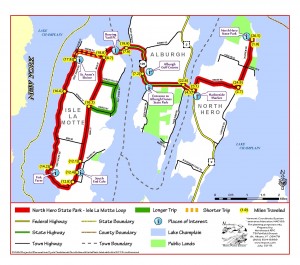
Length of Ride: 27.5 (Also, a shorter option is 17.5 – see notes)
Start / Stop: Start and End at North Hero State Park. Parking available.
(Address: 3803 Lakeview Drive, North Hero, Vermont)
Narrative:
This is a great ride with plenty of lake, mountain and island views; interesting history; a store and a café for nourishment, and; multiple options for restrooms. This is one of my favorite rides for training as well as for casual riding with friends and guests for Sunday morning coffee.
Use white arrows to speed things up.
Starting at the beach in North Hero State Park, turn right onto Lakeview Drive (1.0). Pass by North End Road and turn right onto Bridge Road (2.7). When Bridge Road ends at Route 2 the Harborside Market is on your left (4.5) – great place for drinks, snacks, local conversation, and a clean port-o-let.
Turn right crossing over Alburgh Passage, and in less than a ½ mile turn left onto Route 129. This is a nice cycling road – rolling, initially crossing thru a bog area, past the entrance to Alburgh Dunes State Park, and then broad views of the lake, the bridge to Isle la Motte, and its’ East shore. Pass by the golf course (7.2) and then turn left to cross the bridge onto Isle La Motte (7.6). Be sure to stop at Burying Yard Point on the south end of the bridge to read the memorial plaque for St. Anne’s Fort.
Continue on Route 129 (Main Street), passing Shrine Road (8.7) on your right. For the shorter option, turn right here for a 1 mile out and return to the Shrine.
Pass thru Isle La Motte village (10.3), passing School Street on your right. In just about a half mile you’ll ride thru a wetland. The road was raised here after being submerged under 3 feet of water in the Great Flood of 2011.
Passing by Quarry Road on your left (12.1) you’ll soon arrive at the South End Café (12.4) where you can stop for drinks, baked goods, sandwiches, a bathroom, apples in the Fall, and some more great local conversation. A really great stop!
Continue on Main Street . The road turns to hard packed gravel (12.8) for a little more than a mile, and on this stretch you’ll pass the Fisk Farm. There is a great roadside marker relating Teddy Roosevelt’s visit, and musical performances on Sunday afternoons in the Summer.
The road turns back to pavement (14.2) and you’ll now have a great stretch of road along the West shore of Isle La Motte with wonderful lake views across to Chazy, NY.
Keep left (16.6) where School Street intersects (and stop to read the historical marker about lake ferries of yore!), and arrive at St. Anne’s Shrine (17.8). This is a great place to walk, visit the beach, read the historical markers, and grab a bite to eat in the restaurant. The Shrine, originally a Fort established in the mid-1600s, has great historical significance. Be sure to “Google” it before you arrive.
Continue on West Shore Road up a short, steep hill to return to Route 129 (18.8) where you will turn left, then back over the bridge, and turn right to stay on Route 129 (19.9).
Turn right onto Route 2 (22.6), left onto Bridge Road (23.1), left onto Lakeview (24.9), and finally a left into the State Park (26.5) to finish a beautiful ride that had great views, all the amenities you need, and a dose of history.
For a little extra mileage and great Easterly views from Isle la Motte:
After passing Shrine Road at mile 8.7, take a left onto Nobles Hill Road, turn right at the bottom of the hill for about a mile of gravel road and some great lake views to the East. Continue onto Church Street for about ¾ mile and then turn left onto Main Street to re-join the main route at Mile 10.3.
Terrain:
Good paved road for all but 1 ½ miles of hard packed gravel. A few very short, steep hills on the return.
Places of Interest:
North Hero State Park 802-372-8727
Harborside Market 802-372-4443
Alburgh Dunes State Park 802-796-4170
South End Cafe 802-928-3091
Fisk Farm 802-928-3364
Saint Anne’s Shrine 802-928-3362
Lodging:
Fisk Farm 802-928-3364
Ruthcliffe Lodge 802-928-3200
Inn at the Isles 802-928-3151
The Old Schoolhouse 802-928-3053
Author: Frank Driscoll


